
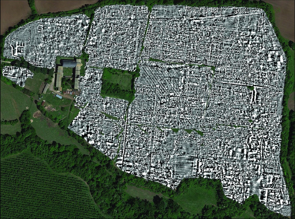
The entire ancient Roman city of Paleri Novi, located 50 km north of Rome, was explored entirely by underground radar and succeeded in creating a beginner level map. It is said that it is impossible to analyze all of the 28 billion data points that are at the beginner level.
Underground data is a method to visualize buried objects and underground structures by measuring internal reflected waves by emitting radio waves to the ground. As a result of exploration of the entire Paleri Novi, structures such as buildings and monuments, as well as passages and water supply system pipes, were revealed back 2,000 years.
As architectural details that have not been known until now have been revealed, unique features not found in other ancient Roman ruins have been discovered, while at the same time it is possible to clearly see how Paleri Novi has changed over the years. It was a non-invasive excavation, as if stepping back in time with a time machine, as if taking an era one by one.
The results were published in the British archaeological journal Antiquity. Paleri Novi was one of the 2,000 cities in the Roman Empire. The existence itself has been recorded in the literature since ancient times. The first appearing in ancient texts was around 241 BC, which was under Roman rule until the Middle Ages, but was abandoned around 700.
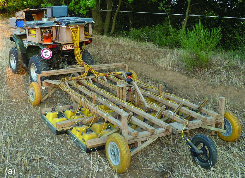
In this investigation, the radar equipment was mounted on an all-weather vehicle resembling a tractor. The area of the site is 30 hectares, and the site is measured every 12.5 cm, containing 28 billion data points. Since there are no forests and no new structures on the surface of Palery Novi, it is also a perfect place to try underground radar technology. This was because it was protected by Italian law, but excavation of ruins was also prohibited.
It was also a suitable place for non-invasive excavation. It may be unreasonable to dig and excavate the soil of all the ruins. Indeed, the famous Pompeii ruins took 200 years to excavate.
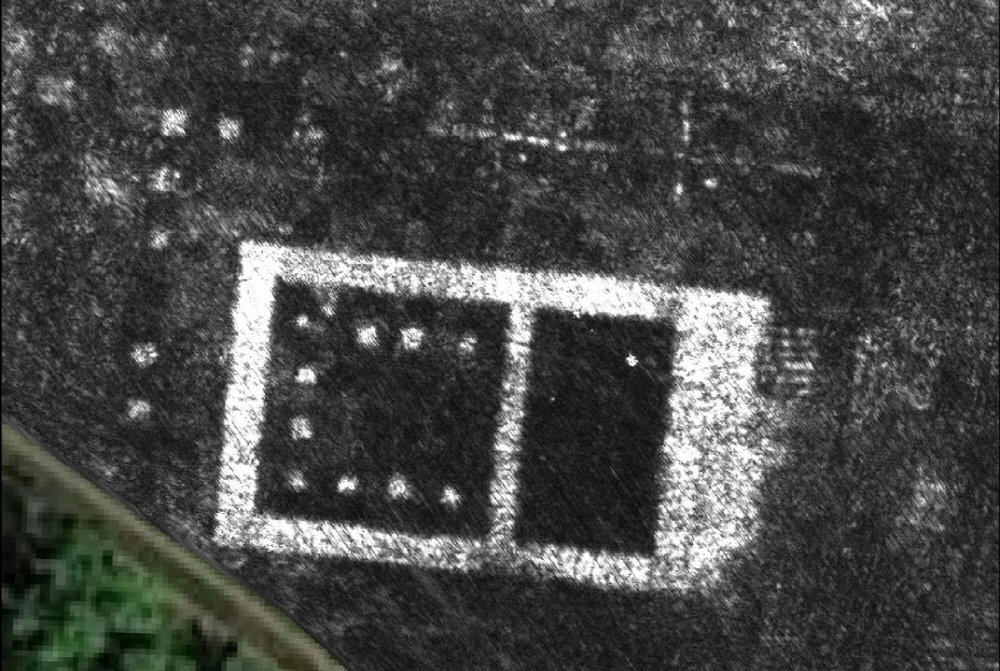
As a result of surveys using geologic data, Paleri Novie found a bathhouse, a market, an open-air theater and downtown, as well as a temple, a large courtyard peculiar to ancient Rome, and atrium dwellings in the outskirts. A large-scale monument was found in the northern part of the village, but the two structures facing each other were not found in any other ancient Roman ruins.
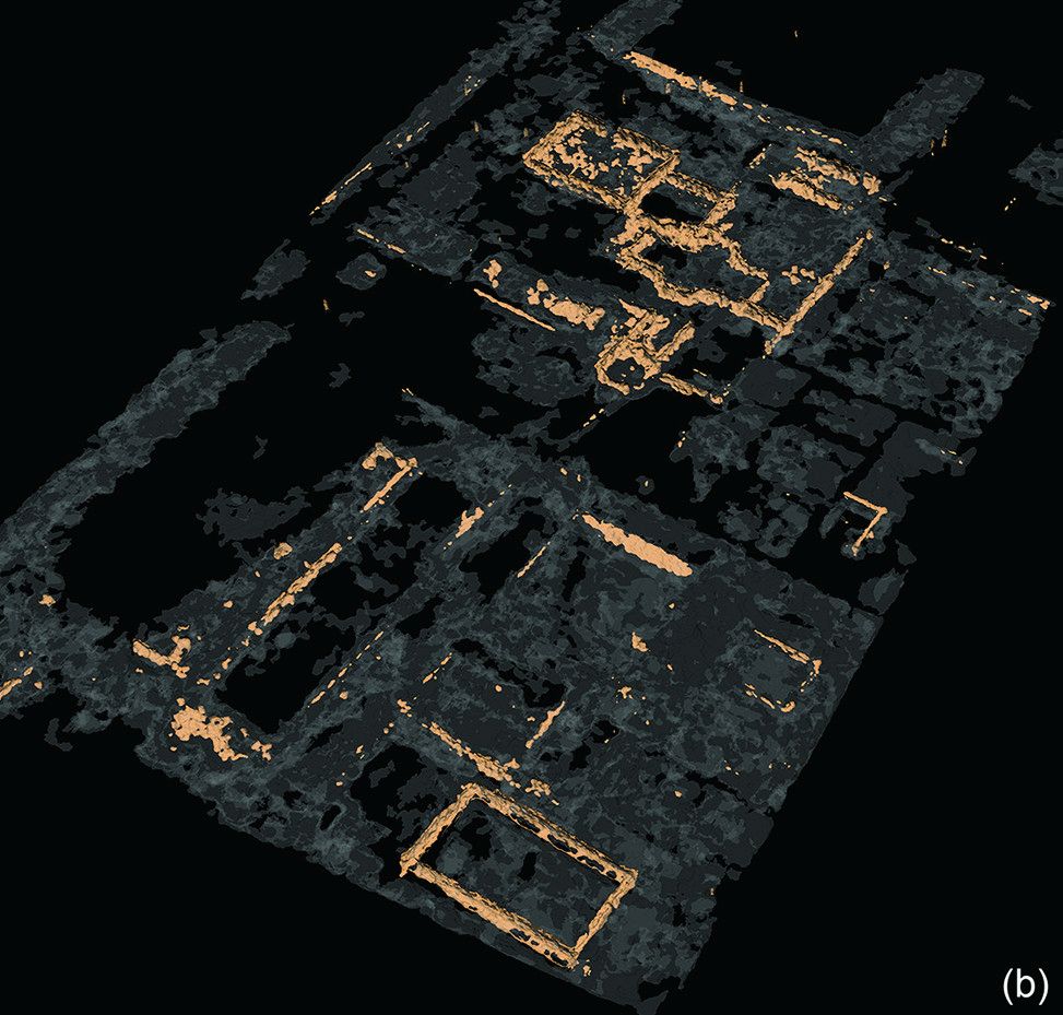
The research team said that one of the importance of this investigation was how ordinary village Paleri Novi was, and were surprised that such an elaborate architectural style existed in an ordinary village during the ancient Roman period. It is also interesting that it was designed in a non-traditional way compared to other ancient Roman cities, although it is ordinary. Sacred places are scattered here. In this investigation, traces of a large building were found in a place adjacent to the castle gate. It is not yet known how these sacred places functioned, but the results of this survey reveal that it was possible to understand that there was no unified urban planning in ancient Rome, and that various urban planning were under way.
The results of this survey are still in its infancy. In the future, some will be automated with computers in order to process vast amounts of data efficiently. As data analysis progresses, there may be more new discoveries. Above all, it is a great achievement just to prove the concept of the meaning of underground radar technology through a ruins survey method. It is possible to see in detail the ancient city hidden under the ground without moving a single stone. Related information can be found here .


Add comment