A research team led by CSAIL at the MIT Computer Science and Artificial Intelligence Laboratory and QCRI at the Qatar Computing Research Institute developed a model that predicts high-resolution collision risk through deep learning. This model can identify areas with high risk of traffic accidents using past magnetic data, road maps, and satellite images, and create a risk map that predicts future accidents.
Despite the low frequency of traffic accidents, losses from traffic accidents account for 3% of global GDP and are the number one cause of death among children and adolescents. According to the research team, the rarity of traffic accidents makes it difficult to create high-resolution maps. If a traffic accident is assumed to occur with a precision of 5 × 5 m, the probability of an accident occurring within one year is 1 in 1,000, and it can be said that an accident rarely occurs in the same place.
The research team used not only accident records, but also GPS trajectory patterns indicating traffic density, speed, and direction, and satellite images indicating the number of lanes, roadside presence, many pedestrians, and road structure. A risk map was created showing the probability of an accident occurring. According to the research team, even in places where there have been no accident records so far, there are areas that have been judged to be at high risk based only on traffic patterns and topography.
The research team pointed out that although attempts have been made to predict the risk of traffic accidents and repeat the map until now, details were blurred and important parts were not seen because the predictions were made with low accuracy of several hundred meters. In contrast, the risk map announced by the research team is in units of 5 × 5 m, and the point is that it has a much higher resolution than before.
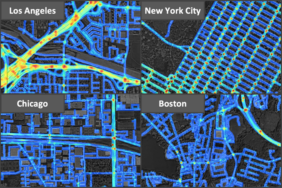
To evaluate this AI model and risk map, the scientists tested its 2019 and 2020 crash prediction performance using data from 2017 and 2018. As a result, it was found that the input data actually occurred in a place where the risk of an accident was recognized as high in an area where no accidents were recorded.
The research team said that this model can predict a collision map in an unknown area by combining several clues from the data. is revealing In addition, if the danger map is used to mark a potentially high-risk road, it can reduce the risk of going out in advance. said to inform Related information can be found here.


Add comment